|
This task describes how to calculate a gap analysis.
|
 |
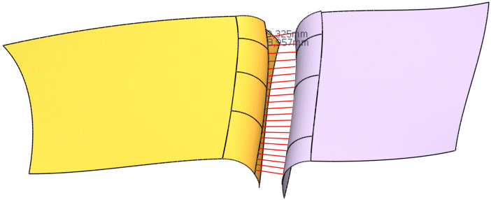
The outer edge of a surface cluster is often filleted with a certain radius. The gap is the shortest distance
between the edge fillets of two adjacent surface clusters. According to the perspective, the gap seems to be wider or narrower.
This analysis function can be used to check how the gap looks from a certain view, and whether it is homogenous, that means
whether the distance between the adjacent surface clusters is always equal along the gap length.
For this purpose, true sections through the surfaces are generated along a guide curve by means of
which distance values between source and target surface are calculated.
Depending on the coordinate system set, the values that are not visible (e. g. at a surface intersection) will be set to 0 (option
System: Model) or only those values that are visible viewed from the chosen plane will be taken into consideration
(options System: Plane/User defined).
 |
Note:
- The surface normals must be adjusted to the outside resp. in direction of the gap, as otherwise the wrong values
will be taken into consideration and set to 0.
- In a true section, the intersection line runs through the intersection point between surface
edge or curve and the normal plane to the curve tangent in this point.

|
|
 |
 |
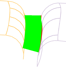
Open the GapAnalysis.CATPart document.
|
 |
-
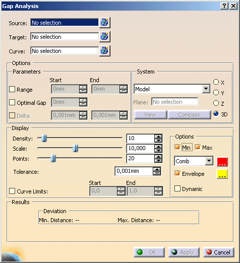
Click the Gap Analysis icon
 . .
The 'Gap Analysis' dialog box is displayed.
|
|
| |
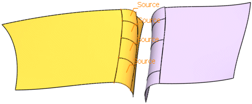
-
Select the surfaces 4 to 7 as Source.
|
 |
| |
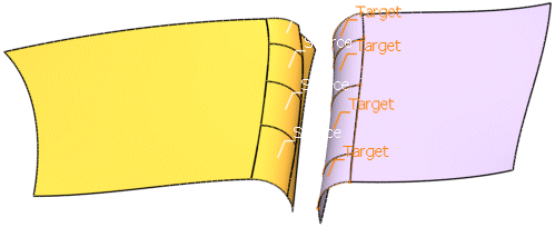
-
Select the surfaces 13 to 16 as Target.
|
 |
| |
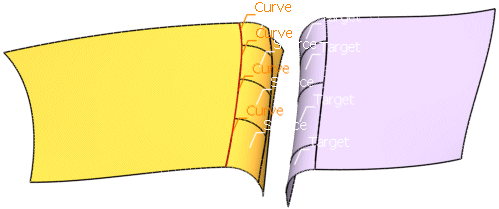
-
Select the edges of the surfaces 4 to 7 as Guide.
|
 |
| |
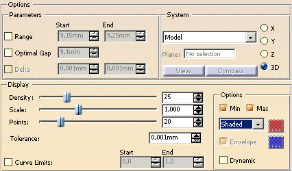
-
Select for the option Density the value 25, as Scale the value
1, for Points the value 20, and select the coordinate system Model.
|
 |
| |
-
Click OK to calculate the Gap Analysis.
|
 |
| |
|
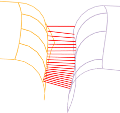
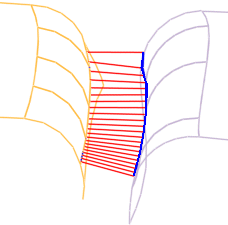
The following steps are carried out in the function workflow:
- True sections are computed through all source and target surfaces.
For this, the specified number of section planes is generated along the guide curve. The section planes (option
Density) are adjusted according to the setting under System.
- Points are then regularly distributed on each individual intersection line on the source surfaces. The number of
sections can be defined with the option Points.
- For each point, the most proximate point of the appropriate intersection line on the target surface will be searched.
This results in the minimum distance value between the surfaces along the section in the System
set.
These minimum distance values are computed for each individual true section and displayed graphically as bars or in
colored representation.
By setting User-defined: View under 'System', the silhouette lines in the current view plane can
be displayed in this way.
- From these values, the minimum and/or maximum value will be computed and numerically indicated afterwards.
|
 |
|
 |
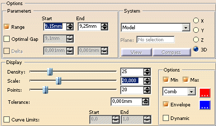
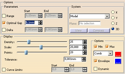
You can define the following options:
- Source: Selection of the original elements for the gap measurement.
- Target: Selection of target elements for the gap measurement.
- Curve: Selection of a curve used as the driving curve along which the true sections are calculated.
- Parameters: For the analysis, you can only switch on one of these options at a time, and not both at the same
time.
Without definition of gap values, the computed total distance values will be displayed. However, you can specify values
for a desired gap. In this case, the deviations from the determined values are calculated and displayed. According to the
display type set, either bars on the source (options Comb/Envelope), or a color
information (option Shaded) is the output result. For the interpretation of the graphical display
of the analysis result please refer to Interpretation of the Gap Analysis.
For the analysis, you can only activate one display type ('Comb/Envelope' or 'Shaded') at the same time.
- Range: Specification of a value range for the optimal gap. Only those values that are
lying outside of the defined range are taken into consideration.
The numerical display at the object indicates the minimum and/or maximum distance value that is independent from the
defined range.
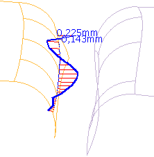
- Optimal Gap: Specification of a particular value for the optimal gap.
At the object will be indicated the optimum value, as well as the minimum and/or maximum deviation from the optimum.
If the corresponding deviation value is lying below the optimum, it will be displayed with a negative sign. If the value
is lying above the optimum, it will be indicated with a positive sign.
- Delta: Additionally, Delta values can be specified for the 'Optimal Gap'. They define
a value range that has the same effect as 'Range':
- Optimal Gap – Delta Min = lower range limit
- Optimal Gap + Delta Max = upper range limit
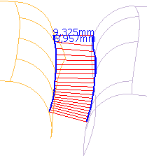
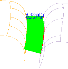
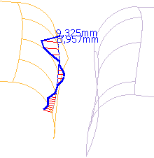
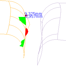
The following figures show the effect of the options 'Range' and 'Optimal Gap': |
| |
Gap Analysis without options 'Range' or 'Optimal Gap'
|
| |
|
| |
Gap Analysis with option 'Range'
|
| |
|
| |
Gap Analysis with option 'Optimal Gap'
|
| |
|
| |
- System: Specification of the direction in which the gap should be measured in.
- Model: When choosing 'Model', no projections are carried out.
- Plane: When choosing 'Plane', a coordinate system is defined by selection of a plane via the selection
field Plane.
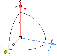
- User defined: With this option, a 3D manipulator is displayed in the graphics area, by which you can define
a user defined coordinate system. In addition, the buttons 'View' and 'Compass' are available:
- View: When choosing 'View', the coordinate system is aligned to the current view
plane.
The lines at the source and target surfaces that are connecting the distance values are nearly identical with the
split lines of these surfaces when setting 'View' and 'Angle' = 0° (see Performing a Split
Analysis). These lines represent the silhouette lines in the current view plane.
- Compass: When choosing 'Compass', the coordinate system is aligned to the current compass plane.
|
Note: The 3D manipulator is independent from the view
and compass position, i. e. in case of view and compass
manipulations the manipulator will not be moved accordingly. |
 |
- X, Y, Z, 3D: Here you can define the component of the minimum and/or maximum distance to be computed and
displayed numerically: the coordinate X, Y, Z, or the 3D value.
- Display
- Density: Number of true sections which are calculated along the selected curve. This
corresponds to the number of values displayed after the computation.
For a dynamic analysis (option Dynamic), the number of saved distance values is shown here.
- Scale: Scaling factor for the display of the distance values.
- Points: Number of points which are regularly distributed on each generated intersection
line on the source surfaces.
- Curve Limits: There is the possibility to use only a part of the selected curve for the calculation. After
activating the check button, the curve can be restricted by moving the manipulators.
Entering values between 0 and 1 defines a relative range that will be applied to topologically contiguous curves.

|
| |
- Options:
- Min, Max: One distance value is generated for each true section through source and target. From all distance
values, the minimum and/or maximum value will be computed and can be numerically indicated.
- Comb: Output of the analysis result as bar information. The displayed lines correlate
with the individual 3D distance values. With the color button, you can choose the line color.
- Envelope: The output of the analysis result as bar information with the option
'Comb' can also be displayed with an envelope. You can choose the envelope color using the color button.
- Shaded: Output of the analysis result as color information. For this, colors are distributed
on the 3D bars framework. The colored display always shows the ratio
- of a measured value to the minimum (WITHOUT Range or Optimal Gap,
- of a measured value to the next range limit (WITH Range), or
- of a measured value to the optimum (WITH Optimal Gap).
The following applies
- System - Model: The 3D distance values are used.
- System - Plane/User defined: The 2D values calculated by projection of the 3D values into the selected
or user defined plane are used.
- Dynamic: After activating this check button you can execute a dynamic gap analysis.
An axis system representing the current section plane is displayed at the guide curve.
The axis system can be moved along the curve tangent.
|
|
| |
- Results: The Results frame displays the minimum and maximum distance of the calculated result.
|
| |
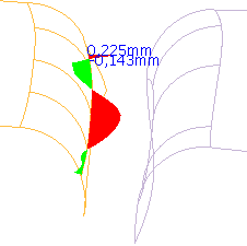
Interpretation of the Gap Analysis
|
| |
| Display of the values |
Length
(3D Framework) |
Direction
(3D Framework) |
Colour |
| Without usage of the options Range or Optimal Gap: |
| all values |
3D distance values |
positive direction |
green: distance values up to the minimum |
| red: distance value from the minimum up |
| Usage of the option Range or the options Optimal Gap and
Delta: |
| values within the range |
= 0 |
– |
–
(connection of the adjacent values) |
| values below the range |
= deviation from the lower range limit |
negative direction |
green |
| values above the range |
= deviation from the upper range limit |
positive direction |
red |
| Usage of the option Optimal Gap without Delta: |
| values below the optimum |
= deviation from the optimum |
negative direction |
green |
| values above the optimum |
positive direction |
red |
|